BOUNDARIES/MAPPING
Boundaries
Property lines should be located, marked, and maintained for a variety of reasons:
Property lines should be located, marked, and maintained for a variety of reasons:
- To minimize trespass from abutting properties.
- To minimize trespass off the property.
- To prevent accidental timber theft.
- To support legal arguments when there is a trespass.
- To minimize the costs of timber sale administration for future sales (lines don’t have to be repeatedly located).
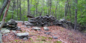
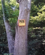
Locating and delineating property lines is sometimes straightforward and easily accomplished if there is a survey, while in other cases a surveyor may be required to locate the property line. Property lines should not be permanently marked unless there is certain evidence, based on a survey, that can be located, such as stone walls, barbed wire, pipes, pins, monuments, etc.
GIS & GPS Mapping

When performing forest inventories, planning timber sales, or locating property lines and points of interest, Global Positioning System (GPS) units allow for the collection of positional data in the field. By combining the efficiency and accuracy of a GPS with a Geographic Information System (GIS) program, a variety of accurate and detailed property maps can be produced that include topographic and aerial photo features. For example, GPS data can be used to designate areas where a stream crossing is required and to calculate timber sale acreage. GPS data can also be used to pinpoint important features such as old homesteads, access points and roads systems, and changes in forest cover type across the property.